×
SparkFun will be closed on Tuesday, December 24th, and Wednesday, December 25th, in observance of the Christmas holiday. Any orders qualifying for same day shipping placed after 2:00 p.m. (MST) on Monday, December 23rd, will be processed on Thursday, December 26th, when we return to regular business hours. Wishing you a safe and happy holiday from all of us at SparkFun!
Please note - we will not be available for Local Pick up orders from December 24th-December 27th. If you place an order for Local Pick-Up we will have those ready on Monday, December 30th.
GPS is one of my favorite nerd subjects, closely followed by anything relating to rocket propulsion. So naturally, I had to dive deeper than our GPS beginner's tutorial. We did some brainstorming on how to take the next step with GPS - once you have a latitude and longitude, you could go ten ways from Sunday with it!
However, instead of delving into the multitude of projects we would like to work on, we asked: How would an everyday person most commonly interact with GPS technology on a day-to-day basis?
The first thought we had was, "What about Google Maps?" Navigation using a GPS system from your mobile device or web browser is an interface that nearly everyone should have some experience with. Much to the delight of GPS enthusiasts or globe groupies, Google Earth gives you the cosmic viewing power of our earth right on the screen. It has tons of features, including geo-mapping capabilities using KML files.
What is a KML file, you might ask? It stands for Keyhole Markup Language and yes, it is similar to HTML (Hyper-Text Markup Language). This format allows us to easily organize our data (altitude, location, atmospheric data, etc.) for Google Earth. There are a lot of functions supported, but we’ll use the placement tool. When your location is loaded into Google Earth, a graphical pin is dropped wherever you are. This is not only a useful feature for knowing where you are in the world and how to get to other places, but you can use your data to log locations of the best hiking trail, the coolest bird watching perch, or the nicest coffee shop in town.
GPS Geo-Mapping at the Push of a Button
September 27, 2019
Let's ramp up our GPS tracking skills with KML files and Google Earth. We'll make a tracker that logs location and allows us to visualize our steps with Google Earth.
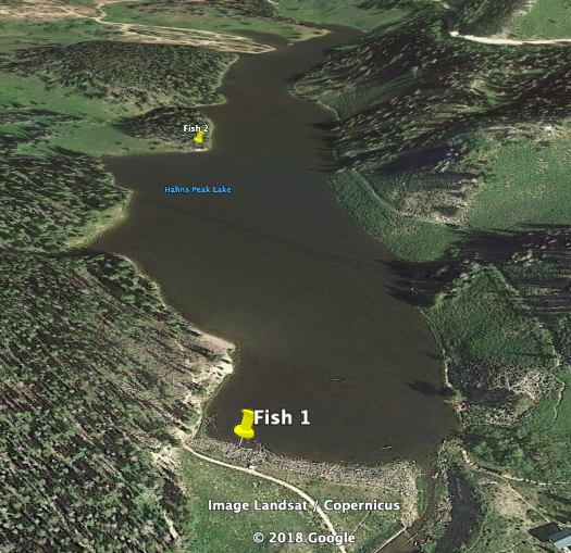
I thought this would be very handy for me as a fisherman. I'm far from having the skills of a professional, but it is one of my favorite hobbies. I’m always on the hunt for the best fishing spot near my home. Luckily for me, there are many lakes and ponds that have potential. The problem is, how do I know which fishing spot is the best?
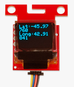
In our first tutorial, I thought it would be handy to create a system where you can push a button and write down the coordinates to log your catches. Perhaps with enough data, I could find the prime fishing spots at my favorite lake. However, using the tools from Google Earth, I can easily push a button and get right back to fishing without the delay of writing everything down!
With enough data and fish caught, I can easily picture myself fishing the day away at the most relaxing, fish-packed lake near my home.
I went fishing up near Steamboat for a nice family vacation. It was catch and release, but it was an even better day of relaxation
Whatever your position, GPS is a fun and useful tool that's widely available to the public. Whether you're casting out a lure or just strolling through a park, put the power of the globe in the palm of your hand today!
Ready to get hands-on with GPS?
We've got a page just for you! We'll walk you through the basics of how GPS works, the hardware needed, and project tutorials to get you started.




Really fun project Brandon!
Which peak is that in the background of your over-lake shot? (And would you happen to have a higher-resolution version of said picture?)
Re: GPS projects: I still have it on my (ever growing) list to create a simple heading-distance indicator to the nearest edge of a box bounded by three or more GPS points. I plan to use it for marking my property edges so we can create trails and such without inadvertently crossing onto the neighbor's land. I figure an RTK-enabled receiver ought to be plenty accurate for that sort of application. :-P
Addressing your project idea: That sounds awesome! I'd like to use an RTK receiver to plot an elevation view of some of my favorite hiking areas (and maybe yard uses for landscaping). Make sure to tag us if you ever post images or updates on the project on social media!
That peak, I believe, is Hahns Peak. The lake is just a few miles north of Steamboat Lake State Park ( https://www.google.com/maps/place/Hahns+Peak+Lake/@40.8382146,-106.9954651,16z/data=!3m1!4b1!4m5!3m4!1s0x8742edc590e97ca7:0xcbe3430f2e93b25f!8m2!3d40.8359287!4d-106.9893594 ). Unfortunately that photo is the only one I have in high resolution. It was originally taken with my phone.
I wish I'd been able to use an RTK receiver to map the GPS points of our house as we were building it, and especially the buried electric, septic, and gas lines. That would have been nice to have a record of!
Absolutely! That would be a great idea.
Unfortunately, we don't have any RTK base stations around my area, and with intermittent internet hosting my own base station didn't seem very practical. Maybe someday I'll figure out a way to make it work before I forget where everything is at.
In theory you could try to use our LTE CAT Shield ( https://www.sparkfun.com/products/15087?_ga=2.6280051.1178768999.1572880791-5961796.1565817435 ) for more internet connectivity. We also have some LoRa options in a tutorial post if you'd like to explore those possibilities, https://learn.sparkfun.com/tutorials/what-is-gps-rtk?_ga=2.17815545.1178768999.1572880791-5961796.1565817435 . Your idea would still be awesome to have. I hope one day you'll be able to implement it.